8-Days Kilimanjaro Lemosho Route 2025-2026

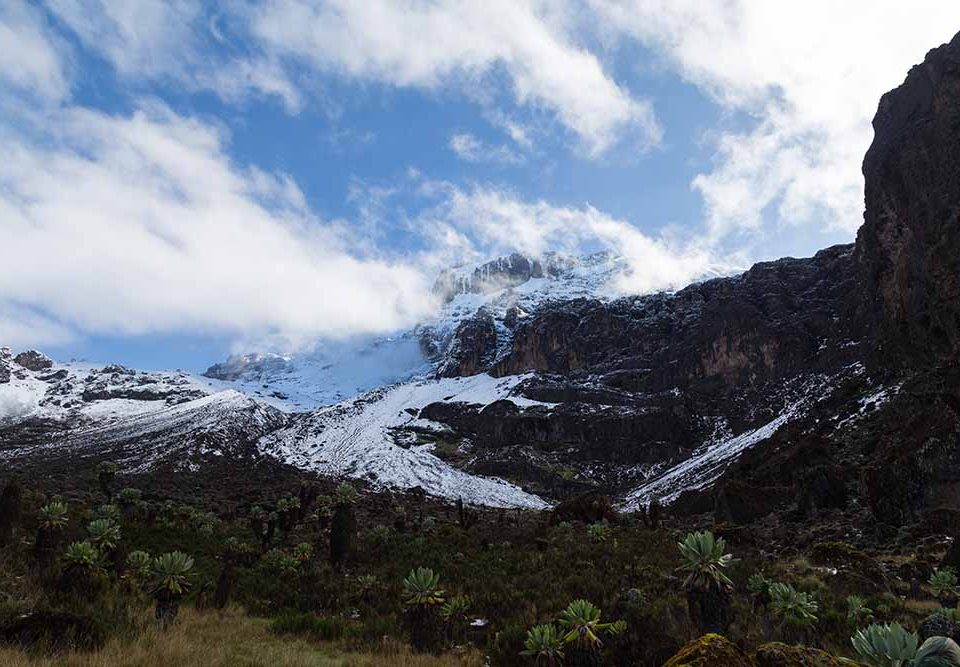
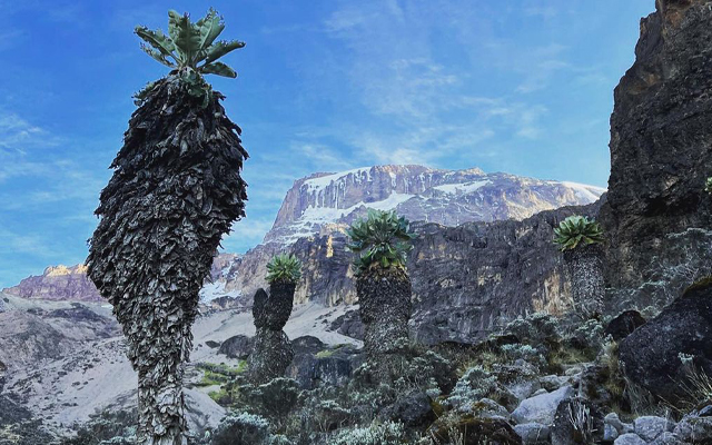
Scenic Views of Kilimanjaro's Western Slopes
The 8-Days Kilimanjaro Lemosho Route is often considered the most beautiful of all Kilimanjaro’s routes. This stunning route, one of the newer options, approaches the mountain from the west, beginning at Lemosho Gate. Unlike the Machame route, it offers a quieter experience, with a greater variety of landscapes and wildlife.
The Lemosho route shares part of its path with the Machame route but has a few advantages, especially for tourists with extra time. The Lemosho Route provides a more gradual ascent, which improves your chances of acclimatization and summit success. The route also offers spectacular views of Kilimanjaro’s diverse ecosystems, from lush rainforests to alpine deserts.
Wildlife enthusiasts will love the Lemosho Route, as it is home to a variety of wildlife. You may spot large buffalo, antelope, and even elephants along the way. The route is also known for its rich biodiversity, including primates like the black and white colobus monkey and blue monkeys, making the trek even more exciting and memorable.
The 8-Days Kilimanjaro Lemosho Route is a great choice for those seeking a scenic and quieter trek to the summit of Mount Kilimanjaro, with excellent chances for wildlife sightings and an overall enjoyable hiking experience. Ready to begin your journey?
Contact us today by emailing info@tanzaniaadventures.co.tz to start your booking process for the 8-Days Kilimanjaro Lemosho Route. Our team will help you plan the perfect adventure!
Join us for an unforgettable adventure to the roof of Africa!
You will be picked up at the Kilimanjaro International Airport and transferred to your hotel in Arusha; you will meet your guide who will brief you on your upcoming trek and do an equipment check to make sure you have all the necessary mountain gear. The missing gear can be rented on this day.
Hotel Accommodation in Moshi: Panama Garden Resort Tanzania
After breakfast and briefing, drive to Londorossi Park Gate, about a 3-hour trip. From here, a forest track requiring a 4WD vehicle leads to Lemosho Glades (2390 m) where you will start your trek through the rainforest.
Walk along forest trails to Mti Mkubwa campsite (2750 m).
Trekking Time: 3 hours | Distance: 7 km | Altitude Gain: 360 m
After breakfast, we continue as the trail’s steepness gradually increases and enters the giant heather moorland zone. After several streams are crossed we continue over the Shira Ridge then gently downwards to Shira 1 camp (3505 m) located by a stream on the Shira Plateau.
Trekking Time: 6-7 hours | Distance: 10 km | Altitude Gain: 755 m
A gentle hike across the plateau leads to Shira 2 camp (3810 m) on moorland meadows by a stream. A variety of short hikes are available on the Plateau, making this a good acclimatization day.
TrekkingTime: 3-4 hours
| Distance: 8 km |
Altitude Gain: 305 m
From the Shira Plateau, we continue to the east, passing the junction near the peak of Kibo. As we continue, our direction changes to the South East towards the Lava Tower, called the “Shark’s Tooth.” Shortly after the tower, we come to the second junction, which brings us up to the Arrow Glacier (4876 m). We now continue down to the Barranco Hut (3860 m). Although you end the day at the same elevation as when you began, this is another important day for acclimatization.
TrekkingTime: 6-7 hours |
Distance: 10 km |
Altitude Gain: 50 m
We start the day by descending into the start of the Great Barranco, a huge ravine. We then exit steeply, up what has been termed the Breakfast Wall. It is a climb over rocks, not technical but long and tiring.
Passing underneath the Heim and Kersten glaciers, we head towards the Karanga Valley (4000 m) overnight.
Trekking Time: 3-4 hours
| Distance: 6 km
| Altitude Gain: 140 m
After a good night’s rest and breakfast, we set off on our walk to Barafu camp at 4640m. The climb will take us across desolate scree slopes with no vegetation around us at all. It’s a tough steep walk made more difficult by the altitude. On arriving at camp we eat and spend the afternoon resting as we prepare for a long night and day ahead. It is important to keep hydrated and warm. We have an early dinner and then try to get some sleep as we will be getting up between 11 pm and 12 pm to start the climb to the summit.
You will be awoken around 23:30 with hot tea and biscuits. Hopefully, you have managed to get a few hours sleep; don’t worry if you haven’t as most people struggle to sleep before summit night. Do however make sure that all your kit, including warm clothes, headlamp, insulated water reserves, and snacks are ready for a sharp departure at 24:00. The trek up Kibo is steep and slow. The trick is to keep your momentum moving forward, one step at a time. It takes about 6-8 hours to reach the top of the crater rim where you will see the sign for Stella Point (5,739 meters). You still have another 156 meters of altitude to walk around the crater rim to Uhuru Peak (5,895 meters). After reaching the summit of Kilimanjaro, a 4.5km / 3-mile ascent, you still have an 11km / 7-mile descent to Mweka Camp (3,100 meters)! Mweka is situated in the upper part of the rainforest zone. The richness of oxygen and moisture in the air will be a very welcome surprise.
In the morning after breakfast, you will be trekking down to Mweka gate. The trek is a pleasant one through the lower rain-forested slopes and down to Mweka Gate (1,640 meters). Although you cover 9km / 5.5 miles, the trek only takes 3-4 hours. Assuming you successfully reach Stella Point or Uhuru Peak you will be presented with official certificates – a green certificate for the former and a gold certificate for the latter. It is customary to tip your trekking crew before being transported back to your hotel in Moshi.
Hotel Accommodation in Moshi: Panama Garden Resort Tanzania
Kilimanjaro Is Climbable All Year Round. The Best Months To Climb Are December-March, And September-October, Which Are The Warmest And Driest Months. The Next Best Are June To August, But They Are Colder. July, August, And September Are The Busiest Months. Summiting On Or Soon After A Full Moon Is Very Beautiful And Helps Illuminate The Landscape Without Using Headlamps. However, It Is Also Very Bright For Sleeping And Stars Are Not As Visible.
Malaria Is A Serious Problem In East Africa So You Must Consult Your Doctor About Getting Effective Malaria Prophylaxis For Your Visit. Many People Are Avoiding Lariam Nowadays And Using Malarone. You Cannot Catch Malaria Above 3000 Metres On Kilimanjaro, But You Must Be Careful Below That Altitude, Particularly If You Visit The Coast Where The Strains Of Malaria Tend To Be Especially Virulent.
Temperatures Range From 25 To 30 Degrees Celsius At The Foot Of The Mountain And -15 To -20 Degrees Celsius On Top Plus Wind Chill. Lower Down, It Can Be Wet And Humid, But Higher Up, There Can Be Snow. Rain And Snow May Be Encountered Any Time Of The Year!
Your Decision Will Depend On Where You Want To Sleep And The Hiking Distance Each Day And Number Of Days Of Each Route. On The Marangu Route, You Sleep In Huts With Simple Beds, While On All The Other Routes, You Sleep In Tents. There Are Two Main Routes On The Mountain: The Marangu And Machame. You May Also Want To Consider The Rongai Route As It Is Far Less Traveled. The Lemosho Route Is A Good Choice If You Want A Longer Route (8+ Days). Kindly Visit Our Kili Routes Page.
Physically, The Marangu And Machame Routes Are Rather Different. The Main Force Of Kibo's Volcanic Activity Occurred Out Towards The West (The Machame Side) And So Machame Is Steeper - Especially In The First Day And A Half - And More Rugged Than Marangu. It Is Often Considered More Scenic Because The Views Of Kibo Are More Impressive Than From The South-East (The Marangu Approach), But Many Consider The Vegetation On Day 2 Of The Marangu Route To Be More Attractive Than Anything Seen On The Western Side. As Always With Mountains, Every Route Has Its Advantages And Drawbacks. The Difficulty Grading Has Marangu As A 1, And Machame A 1+, So There's Not A Great Deal In It.
Always Remember To Maintain A Slow, Steady Pace From Beginning To End. Going Slowly Allows The Body To Acclimatize While Hiking. Those Who Start Out Too Quickly Will Have Troubles Higher Up The Mountain As The Body Will Be Overexerted. This Still Holds True If You Are Spending An Extra Day On The Mountain.
It Will Depend On The Route You Pick And Your Pace. It Can Take From 4-8 Hours To Reach The Summit From The High Camp.
A Weatherproof Jacket, Such As Gore-Tex.
A Woollen Sock That Fits Over The Head With Slits For Only The Eyes And Mouth.
Most Groups Will Start For The Summit On Ascent Day At 11 PM To 12:30AM, Depending On The Perceived Fitness Of The Group, The Weather And The Route. The Pre-Dawn Hours, While Cold, Are Also The Calmest And Clearest. The Best Views From The Summit Are At Dawn. Often Clouds And High Winds Develop Not Long After Sunrise Making The Summit Much Less Attractive And The Descent More Difficult. Guides Who Have Been To The Summit Scores Of Times Report That It Is Very Rare To Find It Cloudy At The Summit At Dawn In Any Season. The Ascent Day Is A Very Long Day Of Hiking. Some People May Require 15 Hours To Reach The Summit And Descend To The Campsite For That Day.
No, But We Can Schedule Transfer From Nairobi By Riverside Shuttles For An Additional Charge.
If A Client Cannot Walk Because They Are Injured Or Sick, At Least Two Support Staff Will Assist This Climber Down. There Is No Extra Charge For Coming Down And Taken Back To The Hotel, But You Will Get No Money Back For That Mountain Days You Missed, And You Will Be Responsible For Medical Assistance And Extra Hotel Nights. We Highly Recommend Travel Insurance To Cover Any Medical Expenses And Further Evacuation
The Typical Tip Is: Porters $10 Per Day Per Porter Cooks $12 To $15 Per Cook Assistant Guides $15 To $20 Per Guide Kilimanjaro Guides $20 Per Day And Up Per Guide *Tip Amounts Listed For Kilimanjaro Are Per Group, Not Per Individual Traveler. For Instance, If Four People Are On Kili, They Should Each Contribute $5/Day If They Want To Tip The Lead Guide $20.
A 30% Deposit Is Required At Time Of Booking To Hold Your Climb/Safari.
